Mount Pavlof se alza a 2519 metros en United States, parte de Alaska Range, North America.
Este pico se clasifica como volcanic.
Altitud
2519 m
Prominencia
— m
Coordenadas
55,418611, -161,893889
Tipo
volcanic
On this page
Comparación de altitudes
Sobre esta montaña
Mount Pavlof (2519m) is a volcanic peak in the Alaska Range, United States. Grade 4/5: technical ascent requiring mountaineering skills. An Alaskan peak set amid vast wilderness, with severe weather and remote approach demanding expedition-level preparation.
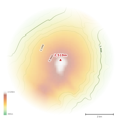
The topographic contour map of Mount Pavlof (2519m) in the Alaska Range shows contours reflecting the unique geological character of the terrain. Contour lines are drawn at 50m intervals, with index contours (thicker lines) every 250m. The hypsometric color scale ranges from green (lower elevations) through yellow and orange to white (highest elevations near the 2,519m summit). Above 2,500m, the estimated snow line at this latitude, contours transition to cooler tones indicating permanent snow and ice.
Perfil de elevación
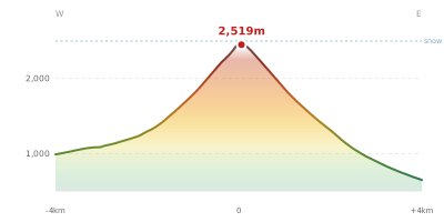
The east–west elevation profile of Mount Pavlof (2519m) in the Alaska Range shows the terrain cross-section through the summit at 2,519m. The color gradient transitions from green (valley floor) to white (summit zone), with the red summit marker indicating the peak. The dashed blue snow line at 2,500m marks the approximate elevation above which permanent snow persists year-round.
Frequently Asked Questions
The contour map uses a hypsometric color scale where green represents lower elevations, yellow and orange indicate mid-range altitudes, and white marks the highest zones near the summit. Thicker contour lines (index contours) are drawn at wider intervals to help you quickly estimate elevation.
The contour map of Mount Pavlof (2519m) uses a 50m contour interval. This means each line represents a 50m change in elevation. Closely spaced contours indicate steeper terrain, while widely spaced contours show gentler slopes.
The elevation profile is a cross-section through Mount Pavlof (2519m) from west to east, passing through the summit at 2,519m. It reveals the mountain's shape, steepness, and relative height compared to the surrounding terrain. The horizontal axis shows distance in kilometers from the peak.
At Mount Pavlof (2519m)'s latitude (55°), the estimated permanent snow line is approximately 2,500m. Since Mount Pavlof (2519m) reaches 2,519m, about 19m of the mountain extends above the snow line. This is shown as a dashed blue line on the elevation profile.